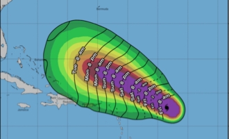
Lee, formerly a Category 1 storm just a day ago, has displayed remarkable intensification in the warm ocean waters, doubling its wind speeds in record time.

Hurricane Lee is projected to intensify further on Friday, rapidly transforming into a formidable Category 5 storm with destructive sustained winds reaching a maximum of 165 mph. This powerful hurricane currently resides hundreds of miles to the east of the Caribbean, as reported by the National Hurricane Center in its 5 a.m. ET advisory.
As of the 5 a.m. update on Friday, Hurricane Lee’s position was approximately 630 miles east of the northern Leeward Islands, according to the hurricane center.
Lee, formerly a Category 1 storm just a day ago, has displayed remarkable intensification in the warm ocean waters, doubling its wind speeds in record time.
Unbelievable Transformation: Tropical Storm Lee Morphs into a Monster Hurricane Overnight!
Within a 24-hour span, Lee gained an astonishing 85 mph in wind speed, tying with Hurricane Matthew for the Atlantic’s third-fastest rapid intensification, as confirmed by NOAA research meteorologist John Kaplan. Notably, Hurricane Matthew wreaked havoc on Haiti in 2016, causing significant casualties and damage in the Caribbean and parts of the US Southeast.
Rapid intensification, defined as a wind speed increase of at least 35 mph in 24 hours, is a phenomenon that has gripped Lee.
Projections indicate that Lee is poised to reach its peak intensity over the coming weekend, maintaining its status as a potentially perilous hurricane in the southwestern Atlantic early next week. However, it remains uncertain whether this system will directly impact the US mainland.
The National Hurricane Center has issued warnings about dangerous surf and rip currents spreading across the northern Caribbean on Friday and affecting the US by Sunday.
There is growing confidence that Lee’s center will pass to the north of the Leeward Islands, the Virgin Islands, and Puerto Rico during the upcoming weekend and early next week. These areas may experience tropical storm conditions, along with life-threatening surf and rip currents during the weekend.
Meteorologists are closely monitoring computer model trends for Lee, which suggest the hurricane may veer north early next week. The timing and extent of this northward turn will significantly influence how close Lee comes to the US.
Here, we delve into the factors steering the storm and outline two potential scenarios that meteorologists are closely observing regarding the potential US threat.
Breaking: Monster Hurricane Lee Set to Unleash Chaos! Brace for Impact
Multiple Storms Stirring in Vast Ocean Regions
While Hurricane Lee swirls in the Atlantic, another storm has earned the name Tropical Storm Margot due to its intensification in the open waters of the eastern Atlantic.
On Thursday, a tropical depression in the eastern Atlantic strengthened significantly, evolving into Tropical Storm Margot, positioned just a few hundred miles west of the Cabo Verde Islands, according to reports from the center.
Margot currently sustains winds of 40 mph, and a steady strengthening trend is anticipated. The center’s forecast indicates that Margot could reach hurricane status by early next week. Importantly, the projected path for the storm indicates a northward turn over the central Atlantic, without posing a threat to any land areas.
In the eastern Pacific, Hurricane Jova maintains its formidable status, albeit far from any potential coastlines, approximately 650 miles west-southwest from the southern tip of the Baja California peninsula.
Now classified as a Category 2 storm, down from its earlier Category 5 strength, Hurricane Jova currently boasts maximum sustained winds of 110 mph as of Friday morning. It is expected to continue weakening as it traverses cooler waters.
