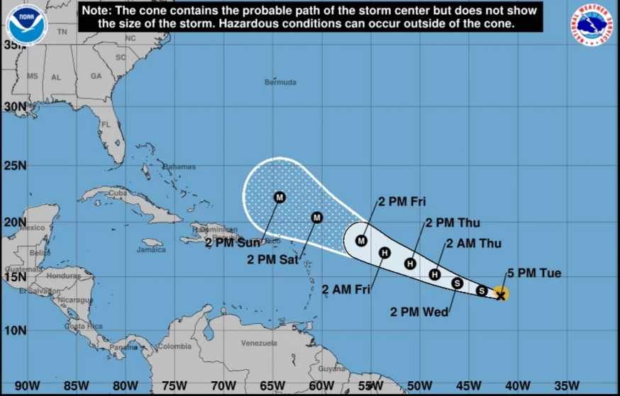
In the Atlantic Ocean, Tropical Storm Lee has officially developed, with meteorologists predicting a swift intensification into a significant hurricane by the upcoming weekend.

Tropical Storm Lee is poised for rapid intensification, potentially evolving into an “extremely perilous” hurricane in the Atlantic Ocean by the upcoming weekend, as forecasted by the National Hurricane Center on Tuesday.
As the hurricane season nears its customary early September zenith, Lee is anticipated to attain hurricane status as early as Wednesday, possibly escalating into a formidable Category 3 storm or even more potent by Friday. These developments are expected to have an impact on the Leeward Islands in the Caribbean during the weekend. With wind speeds potentially surging to 150 mph by Sunday evening, the hurricane center warns of escalating danger.
Also Read:- Bill Richardson, former New Mexico Governor, dies at 75
The tropical storm currently boasts sustained winds of 50 mph, situated approximately 1,230 miles to the east of the Leeward Islands, encompassing the Virgin Islands, Saint Martin, and Antigua and Barbuda. This update comes from the National Hurricane Center’s 11 p.m. ET Tuesday report.
While the precise trajectory remains uncertain, Lee is projected to maintain a west-northwest course across the tropical expanse of the Atlantic until the week’s end, eventually approaching the Leeward Islands with the potential to intensify into a hurricane.
However, any deviations in its path as it approaches the islands could result in a more substantial impact, affecting areas both locally and further afield. Residents in the eastern Caribbean, encompassing the Leeward Islands, Puerto Rico, Hispaniola, and the Bahamas, are urged to closely monitor the evolving forecast.
The potential impact on the US mainland remains uncertain at this juncture. Even if the hurricane remains at sea, the East Coast could still face perilous surf and rip currents, a threat tragically realized with one fatality due to a rip current in New Jersey during the Labor Day weekend.
On Tuesday, Lee transitioned into a tropical storm, having initially developed earlier in the morning within the central tropical Atlantic. The National Hurricane Center attributes this formation to its passage through exceptionally warm waters, and their projections indicate that Lee is poised for rapid intensification.
Also Read:- SHOCKING ARREST: Former YouTube Star Ruby Franke Busted on Disturbing Child Abuse Charges
Rapid intensification denotes a scenario in which a storm’s wind speeds experience a swift and substantial surge within a brief timeframe. In scientific terms, it entails a minimum increase of 35 mph in wind speed within 24 hours or less, a phenomenon significantly influenced by the presence of warm oceanic waters.
As Lee continues its west-northwestward trajectory throughout the week, it will encounter increasingly favorable conditions for bolstering its strength. These conditions encompass ample moisture, minimal wind shear, and notably warm waters spanning nearly the entire length of the projected path for this potential cyclone.
Also Read:- Devastating Blaze Claims 73 Lives, Including Children, in Heart-Wrenching Johannesburg Tragedy
